File:1891 Scotland Languages.jpg
Original file (633 × 858 pixels, file size: 234 KB, MIME type: image/jpeg)
Summary
| Description |
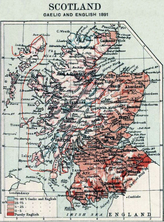
English: Map showing the use of Gaelic and English in Scotland in 1891. In effect, the map shows which areas were bilingual. The shaded areas show what percentage of the population in that area spoke both Gaelic and English.
Note the red line encircling much of the northwest mainland section of Scotland, inside which 50% of the population speaks Gaelic and English. To the south of that area, a smaller percentage of the population spoke Gaelic; to the west of that area, a smaller percentage of the population spoke English. In 1891, Gaelic was spoken by some part of the population across much of Scotland, and especially the northwest. |
| Date | |
| Source | Small inset from Plate IX of J.G. Bartholomew's The Royal Scottish Geographical Society's Atlas of Scotland, Edinburgh: Edinburgh Geographical Institute, 1895 (excerpted and edited). Data based on the Census Report of 1891. |
| Author | John Bartholomew and Son Ltd. |
Licensing
|
This work is in the public domain in its country of origin and other countries and areas where the copyright term is the author's life plus 70 years or fewer.
| |
| This file has been identified as being free of known restrictions under copyright law, including all related and neighboring rights. | |
Original upload log
Transferred from en.wikipedia to Commons by Sreejithk2000 using CommonsHelper.
- 2006-02-16 16:13 Flux.books 633×858× (239907 bytes) Small inset from Plate 9 of J.G. Bartholomew's 'Survey Atlas of Scotland', 1895, excerpted and edited
File history
Click on a date/time to view the file as it appeared at that time.
| Date/Time | Thumbnail | Dimensions | User | Comment | |
|---|---|---|---|---|---|
| current | 13:42, 28 June 2011 | | 633 × 858 (234 KB) | File Upload Bot (Magnus Manske) | {{BotMoveToCommons|en.wikipedia|year={{subst:CURRENTYEAR}}|month={{subst:CURRENTMONTHNAME}}|day={{subst:CURRENTDAY}}}} {{Information |Description={{en|Map showing the use of Gaelic and English in Scotland in 1891. In effect, the map shows which areas wer |
File usage
The following page uses this file:
Global file usage
The following other wikis use this file:
- Usage on en.wikipedia.org
- Usage on hi.wikipedia.org
- Usage on id.wikipedia.org
- Usage on ms.wikipedia.org
- Usage on ur.wikipedia.org