File:WWII in Europe 1939-1941-blank.svg
Jump to navigation
Jump to search

Size of this PNG preview of this SVG file: 702 × 600 pixels. Other resolutions: 281 × 240 pixels | 562 × 480 pixels | 899 × 768 pixels | 1,198 × 1,024 pixels | 2,397 × 2,048 pixels | 1,258 × 1,075 pixels.
Original file (SVG file, nominally 1,258 × 1,075 pixels, file size: 113 KB)
Summary
| Description |
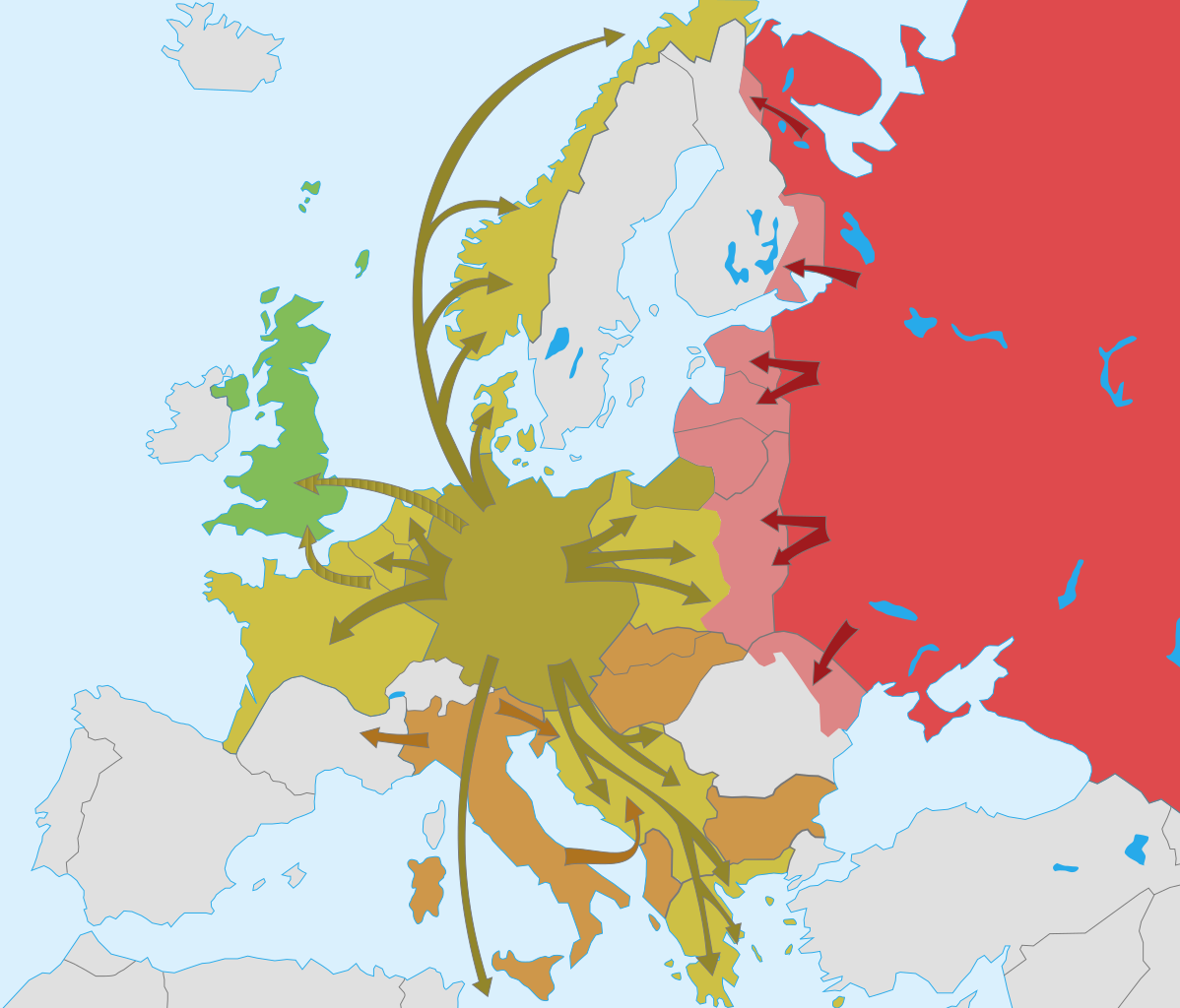
Français : Carte vierge de la Seconde Guerre mondiale en Europe (1939–1941) English: Blank map of World War II in Europe (1939–1941) |
| Date | |
| Source | Own work |
| Author | historicair 23:45, 29 July 2007 (UTC) |
| Other versions |
[]
|


|
This SVG file contains embedded text that can be translated into your language, using any capable SVG editor, text editor or the SVG Translate tool. For more information see: About translating SVG files. |
Licensing
I, the copyright holder of this work, hereby publish it under the following licenses:

|
Permission is granted to copy, distribute and/or modify this document under the terms of the GNU Free Documentation License, Version 1.2 or any later version published by the Free Software Foundation; with no Invariant Sections, no Front-Cover Texts, and no Back-Cover Texts. A copy of the license is included in the section entitled GNU Free Documentation License. |
| This file is licensed under the Creative Commons Attribution-Share Alike 3.0 Unported license. | ||
| ||
| This licensing tag was added to this file as part of the GFDL licensing update. |
This file is licensed under the Creative Commons Attribution-Share Alike 2.5 Generic, 2.0 Generic and 1.0 Generic license.
- You are free:
- to share – to copy, distribute and transmit the work
- to remix – to adapt the work
- Under the following conditions:
- attribution – You must give appropriate credit, provide a link to the license, and indicate if changes were made. You may do so in any reasonable manner, but not in any way that suggests the licensor endorses you or your use.
- share alike – If you remix, transform, or build upon the material, you must distribute your contributions under the same or compatible license as the original.
You may select the license of your choice.
File history
Click on a date/time to view the file as it appeared at that time.
| Date/Time | Thumbnail | Dimensions | User | Comment | |
|---|---|---|---|---|---|
| current | 18:15, 3 March 2017 | | 1,258 × 1,075 (113 KB) | Ras67 | frame removed |
| 23:45, 29 July 2007 |  | 1,256 × 1,075 (140 KB) | Historicair | {{Information |Description={{fr}}Carte vierge de la Seconde Guerre mondiale en Europe (1939-1941) {{en}}Blank map of World War II in Europe (1939-1941) |Source=Own work |Date=30/07/2007 |Author=~~~~ |Permission={{self2|GFDL|cc-by-sa-2.5,2.0,1.0}} |other_v |
File usage
The following page uses this file:
Global file usage
The following other wikis use this file:
- Usage on cs.wikipedia.org
- Usage on en.wikipedia.org
- Usage on fr.wikipedia.org