File:Satellite Sees Two Tropical Cyclones Chase Tropical Storm Daniel - Flickr - NASA Goddard Photo and Video.jpg

Original file (3,072 × 3,072 pixels, file size: 1.2 MB, MIME type: image/jpeg)
Summary
| Description |
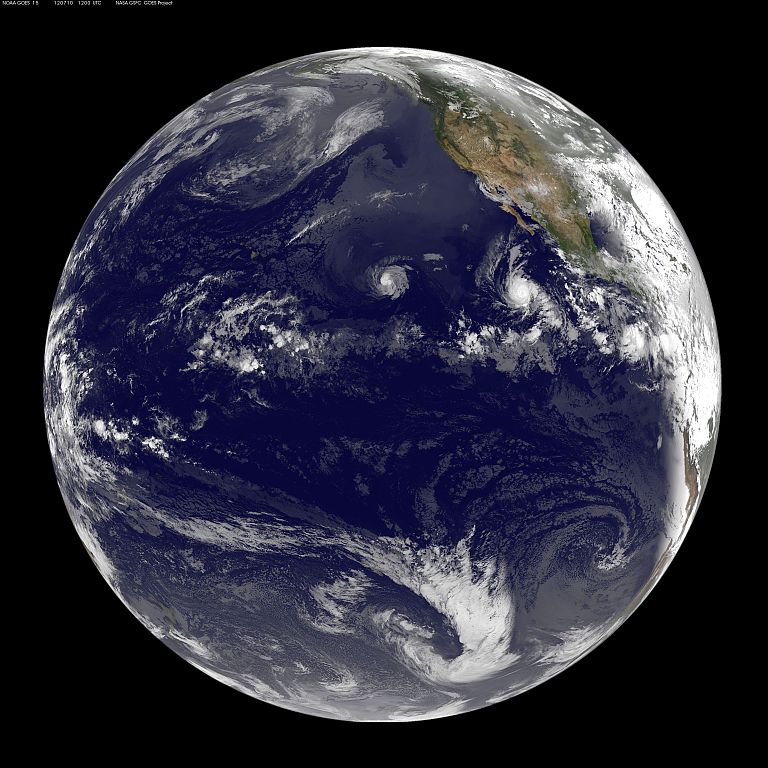
CAPTION: NOAA's GOES-15 satellite captured the three tropical cyclones spinning in the eastern Pacific Ocean today, July 10, 2012 at 1200 UTC (8 a.m. EDT). Tropical Storm Daniel is farthest west, followed by major hurricane Emilia, and developing low pressure System 98E. Credit: NASA/NOAA GOES Project More information: A panoramic satellite image shows an active eastern Pacific Ocean with three tropical systems that appear to be chasing each other. Tropical Storm Daniel approaching the central Pacific Ocean, with major Hurricane Emilia further east, and a developing low pressure area east of Emilia. In an image captured by NOAA's GOES-15 satellite, all three tropical cyclones were seen spinning in the eastern Pacific Ocean on July 10, 2012 at 1200 UTC (8 a.m. EDT).Daniel has weakened from a hurricane to a tropical storm and appears smaller than Hurricane Emilia. Daniel is about 180 miles in diameter, while Emilia is over 250 miles in diameter. System 98E, the low pressure system east of Emilia, is dwarfed by the large hurricane. NOAA manages the GOES-15 satellite, and NASA's GOES Project at the NASA Goddard Space Flight Center in Greenbelt, Md. uses the data to create images and animations of weather around the U.S. Tropical Storm Daniel's winds were now down to 65 mph (100 kmh). At 8 a.m. PDT/11 a.m. EDT, the center of Tropical Storm Daniel was located near latitude 15.3 north...longitude 135.1 west. That's about 1,350 miles (2, 175 km) east of Hilo, Hawaii. It is moving west near 16 mph (26 kmh) and is expected to keep moving in that direction over the next couple of days. Daniel is expected to weaken to tropical depression status by July 11. On July 10 at 5 a.m. EDT, Emilia's maximum sustained winds were near 140 mph (220 kmh). By 11 a.m. EDT, Emilia's maximum sustained winds dropped to 130 mph (215 kmh) and was still holding onto Category 4 hurricane status. Emilia was located about 685 miles (1100 km) south-southwest of the southern tip of Baja California. Emilia is moving at 10 mph (17 kmh) to the west-northwest. System 98E is slowly coming together, and has a 40 percent chance of becoming a tropical depression in the next day or two. Rob Gutro NASA Goddard Space Flight Center NASA Goddard Space Flight Center enables NASA’s mission through four scientific endeavors: Earth Science, Heliophysics, Solar System Exploration, and Astrophysics. Goddard plays a leading role in NASA’s accomplishments by contributing compelling scientific knowledge to advance the Agency’s mission. Follow us on Twitter Like us on Facebook Find us on Instagram |
| Date | |
| Source | Satellite Sees Two Tropical Cyclones Chase Tropical Storm Daniel |
| Author | NASA Goddard Space Flight Center from Greenbelt, MD, USA |
Licensing
- You are free:
- to share – to copy, distribute and transmit the work
- to remix – to adapt the work
- Under the following conditions:
- attribution – You must give appropriate credit, provide a link to the license, and indicate if changes were made. You may do so in any reasonable manner, but not in any way that suggests the licensor endorses you or your use.
| This image was originally posted to Flickr by NASA Goddard Photo and Video at https://www.flickr.com/photos/24662369@N07/7544195454. It was reviewed on 17 August 2012 by FlickreviewR and was confirmed to be licensed under the terms of the cc-by-2.0. |
| This file is in the public domain in the United States because it was solely created by NASA. NASA copyright policy states that "NASA material is not protected by copyright unless noted". (See Template:PD-USGov, NASA copyright policy page or JPL Image Use Policy.) | ||
 |
Warnings:
|
File history
Click on a date/time to view the file as it appeared at that time.
| Date/Time | Thumbnail | Dimensions | User | Comment | |
|---|---|---|---|---|---|
| current | 20:37, 17 August 2012 | | 3,072 × 3,072 (1.2 MB) | Werieth | == {{int:filedesc}} == {{Information |Description=CAPTION: NOAA's GOES-15 satellite captured the three tropical cyclones spinning in the eastern Pacific Ocean today, July 10, 2012 at 1200 UTC (8 a.m. EDT). Tropical Storm Daniel is farthest west, follo... |
File usage
The following page uses this file: