File:BTC-Pipeline.png

Original file (2,766 × 1,876 pixels, file size: 5.49 MB, MIME type: image/png)
Summary
| Description |
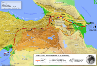
Deutsch: Lage der BTC-Pipeline LicensingProjektionsmethodeKartenbegrenzungen
Code für GMTGlobe-Daten vorbereiten zur Verarbeitungxyz2grd g10g -R0/90/0/50 -I30c -ZTLh -F -N-500 -Gg10g.grd Globe-Datei in *.grd Datei umwandeln grdcut g10g.grd -R25/25/55/50r -Gbtc.grd ausschneiden der relevanten Region (dabei den Kartenausschnitt ein bisle größer gehalten) grdgradient btc.grd -A135 -Ne0.2 -Gbtc_schatten.grd Schatten erstellt Farbtabelle für die Topographie#btc.cpt -571842740023621883 40023621883400013510331 B137175252 F255255255 N137175252 ein kleines bisle abgewandelt bei B und N damit ich mir viel nacharbeiten erspare grd2cpt btc.grd -Cbtc.cpt -R34/34/52/44r -S0/4000/50 >btc_1.cpt erstellen der endgültigen Farbtabelle Topographische Karte erstellenpscoast -JA43/39/24c -R34/34/52/44r -G137/175/252 -S137/175/252 -Df -P -K --PAPER_MEDIA=A3 >btc_topo.ps erstellt eine Karte in der Land- und Meeresflächen den gleichen Blauton haben (in dem Fall ganz praktisch) pscoast -Gc -JA43/39/24c -R34/34/52/44r -Df -O -P -K --PAPER_MEDIA=A3 >>btc_topo.ps wählt für den nächsten Bearbeitungsschritt nur die Landflächen aus grdimage btc.grd -Ibtc_schatten.grd -Cbtc_1.cpt -JA43/39/24c -R34/34/52/44r --PAPER_MEDIA=A3 -P -O -K >>btc_topo.ps erstellt aus den Globe-Daten, der Farbtabelle und der Schattendatei eine topographische Karte (allerdings nur in dem ausgewähltem Bereich, sprich Land) pscoast -JA43/39/24c -R34/34/52/44r -Q -O >>btc_topo.ps hebt die Auswahl wieder auf (wichtig!!!) ps2raster -A -Tg -Gc:\programme\gs\gs8.60\bin\gswin32c btc_topo.ps gibt eine png-Datei aus Globus erstellenpscoast -Rg -JA43/30/18c -B15g15 -Df -P -A0/0/100000 -S200/200/200 -Gblack >btc_earth.ps die Werte für -A (also die Genauigkeit für Inseln und Seen) sind nicht optimal, ich hab aber auf die schnelle keine besseren parat gehabt. Problem: möglichst alle Inseln aber nur die größten Seen sollten erscheinen ps2raster -A -Tg -Gc:\programme\gs\gs8.60\bin\gswin32c btc_earth.ps gibt eine png-Datei aus Restmit den Befehlen: pscoast,pstext,psxy und ps2raster wurden dann noch weitere Karten erstellt die als Vorlage dienten. zum einen um die Orte präzise platzieren zu können, zum anderen um die Erdbeben platzieren zu können und um eine Masstabsanzeige zu generieren |
| Date | |
| Source |
Transferred from de.wikipedia to Commons.
|
| Author | mario |
![[1]](http://www.de.sgs.com/de/bild2-2.jpg)
![[2]](http://www.deutschebp.de/liveassets/bp_internet/germany/STAGING/home_assets/images/karten/btc_pipeline_kartenausschnitt_375xx.jpg)
![[3]](http://home.arcor.de/geonebil/stgeorghilfe/images/tectonic1.jpg)
![[4]](http://www.gfz-potsdam.de/news/foto/tuerkei/Erdbeb.gif)
![[5]](http://141.84.51.10/palmuc/sammlung_geologie/seiten/museum/geoforum/erdbeben/Anatolien2.gif)
Licensing

|
Permission is granted to copy, distribute and/or modify this document under the terms of the GNU Free Documentation License, Version 1.2 or any later version published by the Free Software Foundation; with no Invariant Sections, no Front-Cover Texts, and no Back-Cover Texts. A copy of the license is included in the section entitled GNU Free Documentation License. |
| This file is licensed under the Creative Commons Attribution-Share Alike 3.0 Unported license. | ||
| Attribution: Devil m25 | ||
| ||
| This licensing tag was added to this file as part of the GFDL licensing update. |
Original upload log
- 2008-05-30 09:51 Devil m25 2766×1876× (5754281 bytes)
- 2008-05-28 09:41 Devil m25 2764×1872× (6128772 bytes) ergänzt
- 2008-05-26 09:45 Devil m25 1841×1252× (3462105 bytes) {{Information |Beschreibung = Lage der BTC-Pipeline |Quelle = selbst erstellt |Urheber = |Datum = 05/2008 |Genehmigung = |Andere Versionen = |Anmerkungen = }}
File history
Click on a date/time to view the file as it appeared at that time.
| Date/Time | Thumbnail | Dimensions | User | Comment | |
|---|---|---|---|---|---|
| current | 10:57, 5 October 2010 | | 2,766 × 1,876 (5.49 MB) | Antemister | {{Information |Description={{de|Lage der BTC-Pipeline<br/> == Lizenz: == == Projektionsmethode == * de:Flächentreue Azimutalprojektion === Kartenbegrenzungen === * 34 bis 52 Ö.L. * 34 bis 44 n.B. * '' |
File usage
The following page uses this file:
Global file usage
The following other wikis use this file:
- Usage on ar.wikipedia.org
- Usage on de.wikipedia.org
- Usage on ga.wikipedia.org
- Usage on he.wikipedia.org
- Usage on ka.wikipedia.org
- Usage on lv.wikipedia.org
- Usage on nl.wikipedia.org
- Usage on ru.wikipedia.org
- Usage on ru.wikinews.org
- Usage on www.wikidata.org