File:BspMap-World.png
Jump to navigation
Jump to search

Size of this preview: 800 × 370 pixels. Other resolutions: 320 × 148 pixels | 640 × 296 pixels | 1,357 × 628 pixels.
Original file (1,357 × 628 pixels, file size: 50 KB, MIME type: image/png)
Summary
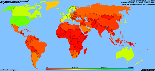
- Light Gray: No data (Vatican City and Western Sahara).
- Dark Gray: Territory disputed or not defined.
Bruttosozialprodukt-Karte / Gross National Product Map (gross capita income per year)
- Highest: Luxembourg with 58,600 $
- Lowest: East Timor with 400 $
- Average: 8,800 $
- World: 55.5 trillion $
Made by ]TRiARii[Redeemer (aka Crazy Frag / DalaiLamer) with Paint Shop Pro 5. For use in Wikipedia, Wikimedia and other opensource projects. (GNU-FDL)
Time needed: 5 hours.
Made in Germany
Copyleft 2005
Licensing
| I, the copyright holder of this work, release this work into the public domain. This applies worldwide. In some countries this may not be legally possible; if so: I grant anyone the right to use this work for any purpose, without any conditions, unless such conditions are required by law. |
File history
Click on a date/time to view the file as it appeared at that time.
| Date/Time | Thumbnail | Dimensions | User | Comment | |
|---|---|---|---|---|---|
| current | 19:12, 15 September 2005 | | 1,357 × 628 (50 KB) | Redeemer | Light Gray: No data (Vatican City and Western Sahara). Dark Gray: Terretory not defined or not clear (China claims to be the owner of both). '''Bruttosozialprodukt-Karte / Gross National Product Map''' ''(gross capita income per year)'' '''Highest:''' Lu |
File usage
The following page uses this file:
Global file usage
The following other wikis use this file:
- Usage on ba.wikipedia.org
- Usage on de.wikipedia.org
- Usage on eo.wikipedia.org