File:Terrorist incidents map of the United States.png
Jump to navigation
Jump to search

Size of this preview: 800 × 365 pixels. Other resolutions: 320 × 146 pixels | 640 × 292 pixels | 1,024 × 467 pixels | 1,280 × 584 pixels | 3,461 × 1,578 pixels.
Original file (3,461 × 1,578 pixels, file size: 2.68 MB, MIME type: image/png)
Summary
| Description |
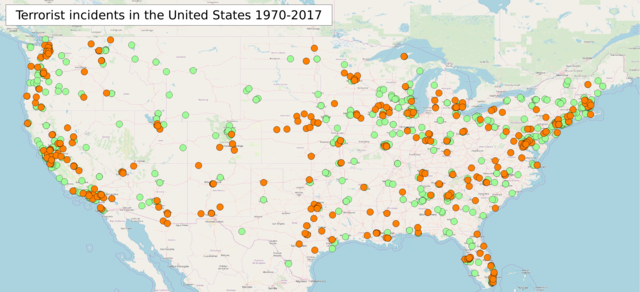
English: Terrorist incidents map of the United States 1970-2017 Orange: 2001-2017; Green: 1970-2000 |
| Date | |
| Source |
Own work
|
| Author | Phoenix7777 |
| Other versions |
|

Licensing
I, the copyright holder of this work, hereby publish it under the following license:
This file is licensed under the Creative Commons Attribution-Share Alike 4.0 International license.
- You are free:
- to share – to copy, distribute and transmit the work
- to remix – to adapt the work
- Under the following conditions:
- attribution – You must give appropriate credit, provide a link to the license, and indicate if changes were made. You may do so in any reasonable manner, but not in any way that suggests the licensor endorses you or your use.
- share alike – If you remix, transform, or build upon the material, you must distribute your contributions under the same or compatible license as the original.
| Description |
English: Terrorist incidents map of the United States |
|||
| Date | ||||
| Source | openstreetmap.org | |||
| Creator |
Own work OpenStreetMap contributors |
|||
| Permission (Reusing this file) |
OpenStreetMap data is available under the Open Database License (details). Map tiles are licensed under the Creative Commons Attribution-ShareAlike 2.0 license (CC-BY-SA 2.0).
This file is licensed under the Creative Commons Attribution-Share Alike 2.0 Generic license.
|
|||
| Georeferencing | If inappropriate please set warp_status = skip to hide. |
File history
Click on a date/time to view the file as it appeared at that time.
| Date/Time | Thumbnail | Dimensions | User | Comment | |
|---|---|---|---|---|---|
| current | 05:19, 16 December 2018 | | 3,461 × 1,578 (2.68 MB) | Phoenix7777 | Updated to 2017 |
| 22:34, 21 October 2017 |  | 1,523 × 660 (563 KB) | Phoenix7777 | User created page with UploadWizard |
File usage
The following page uses this file:
Global file usage
The following other wikis use this file:
- Usage on en.wikipedia.org
- Usage on he.wikipedia.org
- Usage on ru.wikipedia.org