Jump to content

File:Language region maps of India.svg

Page contents not supported in other languages.
From Wikiquote

Original file (SVG file, nominally 512 × 583 pixels, file size: 167 KB)

Render this image in .

This file is from Wikimedia Commons and may be used by other projects. The description on its file description page there is shown below.

Summary

Description
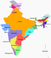
English: States and union territories of India by the most commonly spoken first language.
हिन्दी: भारत के राज्यों और केंद्र शासित प्रदेशों में सबसे अधिक बोली जाने वाली भाषा
বাংলা: ভারতের ভাষা অঞ্চলের মানচিত্র
[1]


Aoː Nagaland (12.94%)
Assameseː Assam (48.81%)
Bengaliː Andaman and Nicobar Islands (25.71%), Assam (28.92%), Tripura (67.14%), West Bengal (85.27%)
Bhiliː Dadra and Nagar Haveli (40.42%)
Chhattisgarhiː Chhattisgarh (61.9%)[2]
Gujaratiː Daman and Diu (67.69%), Gujarat (84.40%)
Hindiː[3][4][5][6] Delhi (80.94%), Haryana (87.31%), Himachal Pradesh (89.01%), Jharkhand (57.56%), Madhya Pradesh (87.26%), Uttar Pradesh (91.32%), Uttarakhand (87.95%)
Bihari: Bihar (73.06%)
Punjabi: Chandigarh (67.53%)
Kannadaː Karnataka (65.92%)
Kashmiriː Jammu and Kashmir (57%)
Khasiː Meghalaya (47.05%)
Konkaniː Goa (57.13%)
Ladakhiː Ladakh (40.4%)
Malayalamː Kerala (96.74%), Lakshadweep (85%)
Manipuriː Meitei (58.43%)
Marathiː Maharashtra (68.79%)
Mizoː Mizoram (73.21%)
Nepaliː Sikkim (62.61%)
Nissiː Arunachal Pradesh (18.97%)
Odiaː Odisha (83.04%)
Punjabiː Punjab (91.69%)
Rajasthani: Rajasthan (90.97%)
Tamilː Puducherry (88.42%), Tamil Nadu (89.41%)
Teluguː Andhra Pradesh (83.85%), includes modern-day Andhra Pradesh and Telangana

References

  1. Report of the Commissioner for linguistic minorities: 50th report (July 2012 to June 2013) (PDF). Commissioner for Linguistic Minorities, Ministry of Minority Affairs, Government of India. Archived from the original on 2018-01-02. Retrieved on 17 September 2016.
  2. Census of India Website : Office of the Registrar General & Census Commissioner, India. censusindia.gov.in. Retrieved on 31 January 2020.
  3. Here the numbers are for Hindi only, not including Urdu. Some languages may be over- or under-represented as the census data used is at the state-level. For example, while Urdu has 52 million speakers (2001) in India, in no state is it a majority. Urdu is mostly used by Muslims. As given in article w:Hindustani language: "w:Hindustani Language is a w:pluricentric language, with two official forms, Modern Standard Hindi and Modern Standard Urdu, which are its standardised registers, and which may be called Hindustani or Hindi-Urdu when taken together. The colloquial registers are mostly indistinguishable, and even though the official standards are nearly identical in grammar, they differ in literary conventions and in academic and technical vocabulary, with Hindi relying more heavily on Sanskrit and Urdu adopting stronger Persian, Turkic and Arabic influences. Hindi uses w:Devanagari script for writing and Urdu uses Perso-Arabic script".
  4. The Cultural Landscape an Introduction to Human Geography by Robert E. Nunley, Severin M. Roberts, George W. Wubrick, Daniel L. Roy, 1999, ( ISBN 0-13-080180-1), Prentice Hall publishers (google books ) quote ... Hindustani is the basis for both languages ...}}
  5. Hindi (google books) by Yamuna Kachru
  6. Students' Britannica: India: Select essays by Dale Hoiberg, Indu Ramchandani page 175
Date
Source Own work, based on the 'Report of the Commissioner for linguistic minorities', Govt. of India,(July 2012 to June 2013)- NCLM-50th report pdf archive copy at the Wayback Machine
Author Filpro
Other versions

Licensing

I, the copyright holder of this work, hereby publish it under the following license:
w:en:Creative Commons
attribution share alike
This file is licensed under the Creative Commons Attribution-Share Alike 4.0 International license.
You are free:
  • to share – to copy, distribute and transmit the work
  • to remix – to adapt the work
Under the following conditions:
  • attribution – You must give appropriate credit, provide a link to the license, and indicate if changes were made. You may do so in any reasonable manner, but not in any way that suggests the licensor endorses you or your use.
  • share alike – If you remix, transform, or build upon the material, you must distribute your contributions under the same or compatible license as the original.

Captions

A Map showing languages spoken in India

Items portrayed in this file

depicts

17 September 2016

image/svg+xml

File history

Click on a date/time to view the file as it appeared at that time.

(newest | oldest) View (newer 10 | ) (10 | 20 | 50 | 100 | 250 | 500)
Date/TimeThumbnailDimensionsUserComment
current17:38, 14 October 2023Thumbnail for version as of 17:38, 14 October 2023512 × 583 (167 KB)SnehrashmiFile uploaded using svgtranslate tool (https://svgtranslate.toolforge.org/). Added translation for gu.
12:22, 4 September 2023Thumbnail for version as of 12:22, 4 September 2023512 × 583 (163 KB)İsnaaaFile uploaded using svgtranslate tool (https://svgtranslate.toolforge.org/). Added translation for tr.
12:52, 27 August 2023Thumbnail for version as of 12:52, 27 August 2023512 × 583 (160 KB)IllchyFile uploaded using svgtranslate tool (https://svgtranslate.toolforge.org/). Added translation for id.
11:42, 25 June 2023Thumbnail for version as of 11:42, 25 June 2023512 × 583 (159 KB)AryanFile uploaded using svgtranslate tool (https://svgtranslate.toolforge.org/). Added translation for as.
11:38, 25 June 2023Thumbnail for version as of 11:38, 25 June 2023512 × 583 (155 KB)AryanReverted to version as of 06:13, 28 December 2020 (UTC). Reason: Actual image was in English where as
11:36, 25 June 2023Thumbnail for version as of 11:36, 25 June 2023512 × 583 (159 KB)AryanFile uploaded using svgtranslate tool (https://svgtranslate.toolforge.org/). Added translation for as.
06:13, 28 December 2020Thumbnail for version as of 06:13, 28 December 2020512 × 583 (155 KB)फ़िलप्रोRemoved Shina as there is no data for the Pakistan-controlled Kashmir region in the Indian census. Chhattisgarhi is treated as a dialect of Hindi as per the Indian census that the map uses as a source.
15:29, 16 November 2020Thumbnail for version as of 15:29, 16 November 20201,476 × 1,680 (249 KB)Sbb1413Adjusted the colour of Kashmiri sphere.
15:25, 16 November 2020Thumbnail for version as of 15:25, 16 November 20201,476 × 1,680 (249 KB)Sbb1413Added Chhattisgarhi, Ladakhi and Shina.
17:00, 5 August 2020Thumbnail for version as of 17:00, 5 August 20201,476 × 1,680 (239 KB)RizoriusFile uploaded using svgtranslate tool (https://svgtranslate.toolforge.org/). Added translation for fa.
(newest | oldest) View (newer 10 | ) (10 | 20 | 50 | 100 | 250 | 500)

The following page uses this file:

Global file usage

The following other wikis use this file:

View more global usage of this file.

Metadata