File:Operation Ivy, Mike cloud, aerial view - NARA - 558592.tif

Original file (3,000 × 2,380 pixels, file size: 20.43 MB, MIME type: image/tiff)
Summary
| Operation Ivy, Mike cloud, aerial view
( |
|||||||||||||||||||||||||||
|---|---|---|---|---|---|---|---|---|---|---|---|---|---|---|---|---|---|---|---|---|---|---|---|---|---|---|---|
| Author |
Unknown USAF personnel: "Personnel conducting this project photography cannot be identified from the project report." |
||||||||||||||||||||||||||
| Record creator | Department of Energy. Office of Public Affairs. (10/01/1977 - 1985?) | ||||||||||||||||||||||||||
| Title |
Operation Ivy, Mike cloud, aerial view |
||||||||||||||||||||||||||
| Description |
English: The picture shows an mushroom cloud of the Mike shot. This aerial photography was taken on of of the two C-47s which were used during the mission to document the explosion. These planes featured the codenames SS-1 (saltshaker one) and SS-2 (saltshaker two). Most of the photographic material taken during the mission was unusable due to different technical issues. The handheld Graflex Pacemaker Speed Graphic cameras shot one image each image minute starting with 07:15 A.M local time. The Test Servive Unit Photo Element was assigned to "Project 3.2 Cloud phenomenon" - one of Operation Ivy's tactical goals to document the cloud development after the explosion. The mushroom cloud on the image is about 3 miles in diameter and 80,000 ft in height. Due to focal length of the lenses and the increasing size of the cloud, any pictures taken after M+10min could no longer display the whole mushroom. |
||||||||||||||||||||||||||
| Date | 1 November 1952, 07:20 | ||||||||||||||||||||||||||
| Dimensions | height: 4 in (10.1 cm); width: 5 in (12.7 cm) | ||||||||||||||||||||||||||
| Collection |
|
||||||||||||||||||||||||||
| Notes | The color negative for this image is "374-ANT-21-APB-35-55." | ||||||||||||||||||||||||||
| Record ID |
|
||||||||||||||||||||||||||
| References | |||||||||||||||||||||||||||
| Source | U.S. National Archives and Records Administration | ||||||||||||||||||||||||||
| Other versions |
Please do not overwrite this file: any restoration work should be uploaded with a new name and linked in this page's "other versions=" parameter, so that this file represents the exact file found in the NARA catalog record to which it links. The metadata on this page was imported directly from NARA's catalog record; additional descriptive text may be added by Wikimedians to the template below with the "description=" parameter, but please do not modify the other fields.
|
||||||||||||||||||||||||||

.jpg)
| Camera Model | Graflex Pacemaker Speed Graphic 4 x 5 (serial number 839232 or 872293) |
|---|---|
| Lens | Kodak Ektar 127mm f/4.7 (serial number RC7785) or Graflex Optar 135mm f/4.7 (serial number 752534) |
| Focal length | 127mm or 135mm |
| Notes | The camera data sheets indicate that a Kodak Plus-X emulsion was used for these photographs. Yet the Plus-X film by Kodak is a dedicated black and white film. Depending on the plane from which this image was taken, it's either the Kodak or Graflex lense. Both airplanes featured the same camera model. |
| Object location | | View this and other nearby images on: OpenStreetMap |
|---|
Licensing
This file was provided to Wikimedia Commons by the National Archives and Records Administration as part of a cooperation project. The National Archives and Records Administration provides images depicting American and global history which are public domain or licensed under a free license.
|
This image or file is a work of a U.S. Air Force Airman or employee, taken or made as part of that person's official duties. As a work of the U.S. federal government, the image or file is in the public domain in the United States.
|
 |
File history
Click on a date/time to view the file as it appeared at that time.
| Date/Time | Thumbnail | Dimensions | User | Comment | |
|---|---|---|---|---|---|
| current | 19:10, 23 September 2011 | 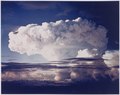 | 3,000 × 2,380 (20.43 MB) | US National Archives bot | == {{int:filedesc}} == {{NARA-image-full |Title=Operation Ivy, Mike cloud, aerial view |Scope and content= |General notes=The color negative for this image is "374-ANT-21-APB-35-55." |ARC=558592 |Local identifier=434-RF-12A(1) |Creator=Department of Ener |
File usage
The following page uses this file: